


- March 28, 2013
Clotten’s 1868 Viticultural Map of the Saar and Mosel
- by Lars Carlberg
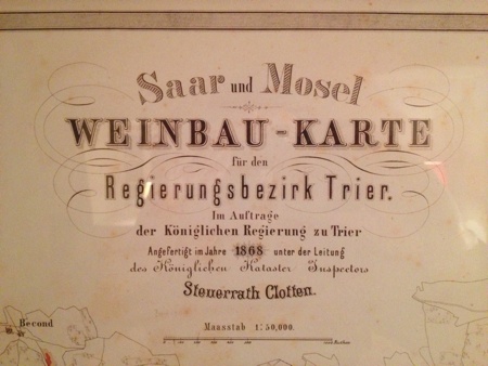
 In collaboration with the nearby Trier Public Library, I'm offering a second reprint of the first edition, printed in 1868, of Franz Josef Clotten’s Saar und Mosel Weinbau-Karte (Viticultural Map of the Saar and Mosel) for the administrative district of Trier. Clotten's official title was Steuerrath, or Royal Land Survey Inspector and Tax Official.
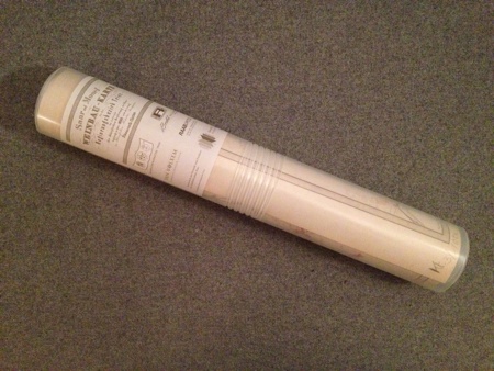
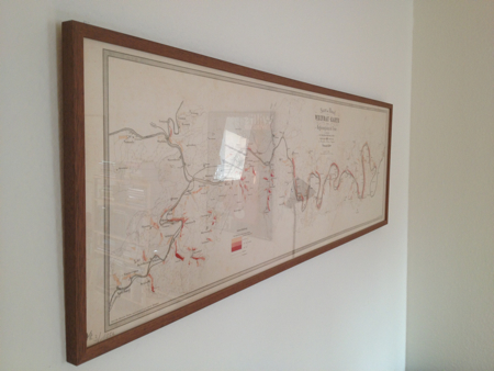
This facsimile of the 19th-century cadastral map of the Saar and Mosel, which includes the Ruwer, comes rolled up in a transparent, cylinder-shaped plastic case in order to avoid creases and can be framed on a wall for study. The map covers the area from Saarburg to Reil, as well as a small section of today's Upper Mosel, between Temmels and Igel.
In Germany, the cost of the map is 35 euros (including tax), plus shipping. For international shipments, the amount is 47 euros (about $50), which includes shipping. The map (circa 148 x 40 cm) also has an essay in German, English, and French. To order, please email me at lc@larscarlberg.com.
Steuerrath Clotten's cadastral map of the Saar and Mosel was first printed in 1868. It was commissioned by the Kingdom of Prussia and went with Otto Beck’s book titled Der Weinbau an der Mosel und Saar (Viticulture on the Mosel and Saar), published in 1869. (Friedrich Wilhelm Dünkelberg's Rheingau map was printed in 1867.*) In contrast, the famous Bordeaux classification of 1855 was a ranking of estates, even though it implied that certain châteaux had better vineyard land than others.
The Prussian tax authorities used the revenue figures of the different Mosel vineyards from the time span between 1816 and 1832 to set up property taxes. The 1868 vineyard tax map was the first of several editions from the cartographer Adam Georg Dienz. The first edition was published in Berlin by Glasener, the others by the publisher Jacob Lintz in Trier, who also owned an estate on the Saar, with holdings in the side-valley site of Wawerner Herrenberg. The fourth and last edition was printed in 1906 (about which, more later).
Clotten ranks the vineyards in eight tax brackets, based on the net income—including yields and labor costs, not just the quality and price of the wines—although the eight classes were simplified down to three for the purposes of the map and marked from highest to lowest in dark red, light red, and beige. Beck wrote that all the well-known sites were listed by name. Some of these sites, such as Scharzhofberg and Maximin Grünhäuser Abtsberg (then called Maximin Grünhäuser Herrenberg), were color-coded as dark red, but Clotten lists the names of the hillsides on the map, like Scharzberg and Grünhausberg (in the Saar and Ruwer valleys, respectively). He does the same for other vineyards, such as Kartäuserberg. In addition, some sites that are now highly thought of were ranked low, if at all. On the Saar, for example, Kanzemer Altenberg and Saarburger Rausch were not even listed. The wines from "Canzemerberg" would later gain recognition, whereas what is today Rausch remained lower priced and lower ranked. Today, the VDP, a leading growers' association, rates both vineyards as Grosse Lage, similar to Burgundy's grand cru, as do many connoisseurs of Mosel Riesling. Yet other sites, which were once considered great, such as several vineyards in and around Oberemmel, such as Agritiusberg, Rosenberg, and Raul, have less acclaim nowadays.
The map has its roots in an order given by Prince Clemens Wenceslaus, Archbishop-Elector of Trier, in 1780, which differentiated between two classes of vineyards. In 1808, under Napoleon, the French published a ranking of the Mosel's vineyards into ten classes by village; alone at the top was Brauneberg, then called Dusemond. (Before 1925, Brauneberg referred only to the hillside.)
Furthermore, wine author Joachim Krieger has recently republished the fourth edition (1906) of Clotten’s 1868 Saar and Mosel map and the second edition (1908) of Eduard Markworth's 1897 Mosel map of the administrative district of Koblenz, which runs further downriver from Traben-Trarbach to Koblenz. Both of these later editions show the Mosel at its height. The Prussian Staatsdomäne (State Domain), for instance, cleared Lohhecken, or oak shrubs, for new Riesling vineyards on various slate slopes in side valleys. These included new plantings in Ockfen (Heppenstein) and Serrig (Schlossberg and Vogelsang) on the Saar and in Avelsbach (Hammerstein and Rotlei), nearby Trier. (The State Domain has since sold its properties in Ockfen and Serrig.) Today, some first-rate sites even lay partly fallow, like Ockfener Geisberg, which will be replanted by Van Volxem and Markus Molitor (see "The Rebirth of a Riesling Legend" for more details). Krieger plans to sell these two maps together in a folder with his three-page manifesto, which he hopes to have completed soon (for an update, click here).
In the meantime, you can buy a reprint of the first edition of Clotten's Saar and Mosel map from 1868. The original was a folded map, and the first reproduction by Stuart Pigott and Hugh Johnson was the same. Subsequent unfolded printings have these crease marks, which have since been erased on the latest copy for sale. My thanks to the Society of Friends and Patrons of the Trier Public Library (Stadtbibliothek/Stadtarchiv Trier) for commissioning this second reprint. ♦
>> Clotten's 1868 Viticultural Map of the Saar and Mosel (Second Edition)
* In 2011, Daniel Deckers, a journalist at the Frankfurter Allgemeine Zeitung, discovered Dünkelberg's Rheingau map in the Wiesbaden State Library. It was printed in Wiesbaden in 1867 for the Duchy of Nassau to show the glory of the famous Rheingau wines for the International Exposition of 1867 in Paris. Unlike Clotten's 1868 Saar and Mosel map, Dünkelberg classified the Rheingau vineyards (by district and site) in three categories based on prices instead of net yields (see also "Tranchot Map").
- Posted in Articles, Mosel
- | Tagged: Franz Josef Clotten, Joachim Krieger, maps
As mentioned in my article above, there is the 1897 Mosel cadastral map of the administrative district of Koblenz, which shows the lower part of the Middle Mosel (Traben-Trarbach and Enkirch) and all of the Lower Mosel. In addition, there is the 1910 Mosel and Sauer map of Luxemburg, which is the Upper Mosel, but it only really highlights the vineyards on the left bank, or Luxembourg side of the Mosel. (Sign up for free to read an overview of the Mosel wine region, including several comments.)
And then there are the Mosel and Saar maps from this period that marked the vineyard areas in green but made no attempt to classify the sites. These were printed in Trier, too, but are no longer available for sale as reprints. As director for viticulture in the Prussian Rhine Province, Friedrich Wilhelm Koch (no relation to Karl Heinrich Koch) wrote Der Weinbau an der Mosel und Saar (Lintz, 1881), a detailed volume, with a fold-out map, about winegrowing in the Mosel and Saar. He later made with the publisher Heinrich Stephanus (also based in Trier) the first extensive viticultural map of the Mosel and Saar regions, which had the vineyards marked in green. One original, at the Trier municipal archives, is a leather-bound scroll from 1897. Koch’s map competed with the Prussian tax maps. In the early 1950s, a similar map with the Riesling vineyards marked in green and the Kleinberger (Elbling) marked in yellow was printed by Lintz.
Friedrich Wilhelm Koch and Heinrich Stephanus also had a separate book that accompanied their maps. The title is Die Weine im Gebiete der Mosel und Saar. The third edition was published in 1914.
Reinhart Löwenstein graciously sent me a copy of an 1897 Regierungsbezirk Coblenz map together with a monograph he wrote about the geology of the area and its primitive structure before Europe became more of a solid continent. I’m assuming that this is the map to which you refer.
The idea of using matte glass is a wonderful one. I matted and mounted my two maps together in a rather awkward about 4 x 3 feet and it’s always been difficult to use because of the glare from my uv-proof glass. I’m wondering if the prospective maps being discussed here can be mounted.
The theories of Roman Niewodniczansky of van Volxem concerning the Wawerner Goldberg and the Fischer Eingetragene Marke (trademark) called Wawerner Goldberg, supplemented from what I’ve learned from Jean Fisch, are fascinating, complex, and worth their own monograph if you haven’t already done this. The Wawerner Goldberg vineyard from which Roman makes his wines and from which he made his marvelous VDP Auction Goldberg Auslese 2007 is not the same as the site from which Dr. Fischer made their trademark wines. I’ve visited the site with Roman and have examined some of the copies of older maps from that area in that earlier era.
Sorry for the confusion contained in my comment. Of course the Herrenberg is the trademark wine that Linz (and Fisher) produced. There probably is overlap between the names Herrenberg and Goldberg. Lars, your comments in the Bergretten notes is more accurate by far than my off-the-shoulder recollections of my talk with Roman and Jean Fisch of several years ago. jht
It’s no problem. As you noticed, I mentioned Roman Niewodniczanski of Van Volxem and Wawerner Goldberg in my article titled “Bergretter (Addendum).”
Yes, John, that’s the same 1897 Mosel map of the district of Koblenz. I’ve two rolled-up copies of the first edition, plus one folded version of the second edition (1908). Speaking of Reinhard Löwenstein, he criticized me for offering only the 1868 Saar and Mosel map on my site. I, however, had to explain to him that I’m a big supporter of the Lower Mosel and I’ve purchased numerous copies of his maps for clients over the years. For example, the one hanging at Chambers Street Wines in NYC is from me. I just happen to live nearby the Trier library, which asked me to help sell its stock of the 1868 Saar and Mosel tax map.
My 1868 Saar and Mosel map has no glass or frame. It’s just mat with a protective film (see photo).
The 1910 map, Mosel & Sauer Weinbau-Karte des Grossherzogtums Luxemburg, made by H. Schliep has four classes of vineyards, colored yellow to brown. The map covers the Prussian vineyards (all in class 4) on Obermosel and Mosel-Tor, but does not mention any site names there. However, in Lorraine (Lothringen), three sites are named. Schliep’s map has the same scale as Clotten’s, 1:50,000, which makes it a nice fit to the other Mosel maps.
The other day, I spoke briefly with Joachim Krieger about the 1910 Mosel & Sauer map. He says that this Luxembourg map is quite one-sided. As you point out, all the vineyards on the Prussian side of the Mosel River are rated low.
By the way, Joachim says that his manifesto for the 4th ed. (1906) of the 1868 Saar and Mosel map and the 2nd ed. (1908) of the 1897 Mosel map should be published before Xmas. It’s titled Die Grösse der Mosel ist die Vielfalt und Dichte ihrer Weinbauorte (The Greatness of the Mosel is the Diversity and Density of its Winegrowing Villages). Each map is folded and 20 percent smaller than the original. Joachim included the vineyards of Traben-Trarbach and Enkirch (both Middle Mosel) on the Saar and Mosel map of the district of Trier. (Back then, both villages were a part of the administrative district of Koblenz.) These later editions, reprinted by Joachim, show the boom years of the Mosel region.
Supposedly, Joachim Krieger has completed his manifesto: “Größe der Mosel” (The Greatness of the Mosel), which goes along with the 4th ed. (1906) of the 1868 Saar and Mosel map and the 2nd ed. (1908) of the 1897 Mosel map. A couple of friends have asked me if this is Joachim’s long-awaited Mosel Riesling book. No, this is just his in-depth essay for the old maps, which will bring to light the importance of these maps and why Mosel wine is so distinctive.
Reply to the Mosel Sauer map: I do not share the view that Henri (or Heinrich) Schliep’s map is one-sided. According to Otmar Werle’s Das Weinbaugebiet der deutsch-luxemburgischen Obermosel (1977; based on his PhD thesis in geography), in 1910, the Prussian right bank had about 360 ha (today 800 ha) of vineyards and Luxembourg 1,620 ha (today 1,200 ha). With this in mind, I feel this proportion is well reflected on the map. On the other hand, it was commissioned to cover only Luxembourg, so the Prussian and Lorraine vineyards are sort of a bonus. By the way, does anybody know if Clotten ever covered the Obermosel?
As far as I know, Clotten only mapped a small section of the Obermosel between Temmels and Igel.
Here is an article I wrote with images of a more detailed cadastral map. I find them fascinating because they illustrate the individual holdings.
Best,
Aaron
Thanks for the link to the images. As I replied to your article, I saw a cadastral map of Wawern from 1820 on a visit to Van Volxem last month. It also shows the various parcels, with rankings, on the hillside vineyard. I wrote about this under Wawerner Goldberg in my new article called “Bergretter (Addendum).”
This summer, I purchased a second copy of Clotten’s Saar and Mosel map from 1868. Instead of putting it in a frame, a friend in Kontanz discovered a shop that puts the map on a HDF board with a mat sealant, a special film from a “hot-vacuum process,” so that the map is protected and doesn’t bleach out. The edges are colored to match the map, and wooden strips of 2-cm thickness are mounted on the backside.
Though I like my framed map (which I now sold to a winemaker friend)—especially the wooden frame that I chose for it—I prefer the mat, frameless version of the map, which can be touched and doesn’t have a glass reflexion.
Supplique on the Mosel & Saar Map: The 1898 edition of Koch and Stephanus map also covers Luxembourg and Obermosel. It corresponds pretty well to Schliep’s map. Link to the map : https://www.dilibri.de/rlb/content/zoom/192259
In the first edition of Die Weine im Gebiete der Mosel und Saar (1898) by Friedrich Wilhelm Koch and Heinrich Stephanus (the latter of whom was the publisher), Koch points out the problems with Clotten’s color map of the Saar and Mosel. The first problem is that each of the 13 classification districts (such as Saarburg, City of Trier, Bernkastel, Zell, or Cochem) didn’t have the same values for the eight tax brackets, based on the net income. In other words, a first-class land tax per morgen (4 morgen equals 1 hectare) in Saarburg was 78, whereas in Koblenz it was 48. The eight tax classes were also grouped together: 1st and 2nd classes in dark red; 3rd, 4th, and 5th in light red; and 6th, 7th, and 8th in beige. Koch says that this only causes “bad errors.” In addition, there were major changes in the vineyard tax assessment of 1861/63. Certain sites were farmed better and more diligently. He gives the examples on the Saar of Canzem (Kanzem), Wawern, and Ayl, which were all in the 4th and 8th classes, but had renowned wines and high prices. The same cannot be said of Saarburg, for example.
As I mentioned in my first comment at the top, F.W. Koch and H. Stephanus had their own Mosel and Saar map. It was printed in Trier and titled Weinbau-Karte von den Gebieten der Mosel und Saar (first edition 1898). The vineyards were all marked in green, instead of being color coded.
In the Saar region, Koch writes that the best sites are mostly in side valleys: Bockstein, Geisberg, Scharzhofberg, Scharzberg, Raul, Oberemmel, Euchariusberg, Wawerner-Herrenberger, Ayler Kupp, plus a large part of the district of Wiltingen. On the Saar itself, he lists Failserberg, nearby Schoden, Wiltinger Kupp, as well as a large section of Canzem.
Koch also lists many more individual vineyard sites than did Clotten and gives the reader a better idea of where those sites were located on a particular hillside.
I should also mention Jules Lavalle’s book, published in 1855, classifying the vineyards of Burgundy (Côte d’Or). In 1861, the Comite d’Agriculture de Beaune made a map based on Lavalle’s work.